Post Archive

Minnesota Class IV Burning Restrictions
August 9, 2021
Contacts: Allissa Reynolds, acting wildfire prevention supervisor, 763-284-7213
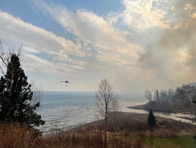
Additional burning restrictions take effect Tuesday in Cook and Lake counties
To help ensure public safety and protect natural resources, the Minnesota Department of Natural Resources is activating additional burning restrictions for areas within state jurisdiction in Cook and Lake counties, beginning 12:01 a.m. Tuesday, August 10. Under the additional restrictions, all campfires and recreational fires are banned and the use of welding devices and other torches is prohibited when in proximity to combustible vegetation (unless special permission is granted). While the DNR’s restrictions do not control tribal lands, the Grand Portage Band of Lake Superior Chippewa has restricted burning on its lands.
Under these additional restrictions, the campfire and recreational fire ban in Cook and Lake counties now includes all public and private land. In the backcountry, and at campsites, only gas or propane camp stoves are allowed. Gas and charcoal grills are allowed at occupied homes, cabins and resorts. Charcoal and gas fires must be in devices designed for grilling.
All previously issued burning restrictions also remain in place for Cook and Lake counties, including:
- No fireworks may be ignited on any public or private land outside city limits. Check with your local community for any additional restrictions.
- The state will not issue burning permits for brush or yard waste. Open burning permits are restricted. Check the statewide fire danger and burning restrictions webpage for more information.
Restrictions on open burning and campfires remain in place for more than twenty other counties in central and northern Minnesota. Some of these restrictions apply to all non-tribal lands, while others are specific to DNR-managed lands. Details are available on the DNR’s wildfire information page.
Allissa Reynolds, DNR acting wildfire prevention supervisor, says these additional burning restrictions are warranted in the Arrowhead Region due to the combination of the high risk of wildfire and landscape features that can make suppressing wildfires there extremely challenging. “This year, we’ve seen wildfires starting from campfires, as well as all types of outdoor activities, which is uncommon and dangerous,” Reynolds said, “Campfire bans on public and private lands are rare and reserved for times of intense wildfire risk, like we are experiencing now. We are implementing these restrictions to protect life and property, and following consultation with our local, tribal, and federal partners.”
Check the DNR statewide fire danger and burning restrictions map before any outdoor activity or before heading to your cabin or campsite. You can make a difference – keep safety at top of mind. People who spot a wildfire should call 911.
Visit the DNR wildland fire information webpage for more information on current restrictions.
Election Judges Needed
Election Judges Needed
Lake County is looking for election judges for the 2026 State Primary and General Elections. If you are interested and available to serve, please complete the Lake County Election Judge Interest Form at: https://www.co.lake.mn.us/auditor/become-an-election-judge/.
4th Street (Hwy 2) Two Harbors – Planned Closure
NOTICE
4th Street (Hwy 2) in Two Harbors will be closed to traffic between 7th Avenue (Hwy 61) and 12th Avenue, including the intersection 12th Avenue (see image attached).
When
Beginning: June 1
Ending: July 17 (estimated)
Purpose
The closure is necessary for the City of Two Harbors and their contractor to complete improvements on city owned water systems.
Work Schedule Details
Work will begin June 1 at 8th and 9th Avenues. Work at 10th, 11th and 12th Avenues will begin June 8th.
Traffic Impacts
A detour route will be posted utilizing 8th Street, Paul Antonich Drive, and 20th Avenue (Hwy 26). 4th Street will remain open to residents and businesses between 12th Avenue and 20th Avenue. Access for residents and businesses with driveways between 8th Avenue and 12th Avenue will be coordinated with project personnel. Access to the hospital will be maintained at all times but will need to be accessed via 10th, 11th or 12th Avenues.
Please contact Zeke Myers at 507-613-8905 or zeke.myers@bolton-menk.com with any project, traffic, or access related questions or concerns.
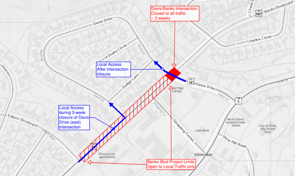
Street Closure Notice – Davis Drive/Banks Blvd, Silver Bay – Beginning May 18 (Update)
UPDATE:
The Davis Drive intersection will not close until later this construction season; an updated closure schedule will be provided when determined. The contractor has developed an updated plan to minimize the risk of water service disruption due the condition of the existing water system and planned pipe replacement work. Utility work is ongoing immediately west of the Banks Blvd and eastern Davis Drive intersection and the intersection will remain open for Davis Drive traffic. Please be aware of construction vehicle traffic and workers entering and exiting the work zone at this intersection.
NOTICE
The Banks Boulevard reconstruction project in Silver Bay will resume with street closures beginning Monday, May 18.
- Davis Drive: Closed to all traffic at Banks Blvd intersection
- Closure duration: 3 weeks
- Access to city hall/police station from Outer Drive
- Access for residents on Davis Drive/Drake Cir via Banks Blvd and west Davis Drive intersection
- Access for residents east of Davis Drive via Adams Blvd.
- Banks Blvd:
- Closure duration: ~3 months
- Closed to through traffic between Edison Blvd and Davis Drive (east).
- Open to local traffic as provided by the contractor.
- Access from west end of construction limits while Davis Drive (east) is closed
- Fire station access always maintained
Stewart Trail Fire – Thursday, June 4th 2026
Stewart Trail Fire Debris Disposal Information
As part of the ongoing Stewart Trail Fire response and recovery effort, Lake County, in coordination with the Minnesota Department of Public Safety and the Minnesota Pollution Control Agency, has established temporary disposal sites for fire-related debris.
Where Can I Dispose of Burned Debris?
Emergency Temporary Transfer Station
Location: Lake County Demolition Landfill, West Castle Danger Road
Hours: Tuesday and Thursday, 10:00 a.m.–5:00 p.m., or by appointment. For appointments, contact Environmental Services at 218-834-8304.
Open through July 2, 2026
No disposal fees will be charged for eligible burned debris.
Accepted materials:
- Burned non-vegetative debris that cannot be accepted at the Recycling Center or the established landfill disposal sites
- Burned building materials
- Demolition debris
- Fire-related ash
This temporary site is available only for properties impacted by the Stewart Trail Fire. Staff will ask for the property address to verify eligibility.
Emergency Temporary Transfer Station Map
Lake County has received approval from the Minnesota Pollution Control Agency to establish this temporary disposal area for burned building and demolition materials from Stewart Trail Fire-affected properties.
Please use the Recycling Center and other designated landfill disposal areas whenever possible for materials accepted at those locations.
Important: The Temporary Transfer Station will close on July 2, 2026. After that date, burned building materials, demolition debris, and ash will no longer be accepted at the Lake County Demolition Landfill.
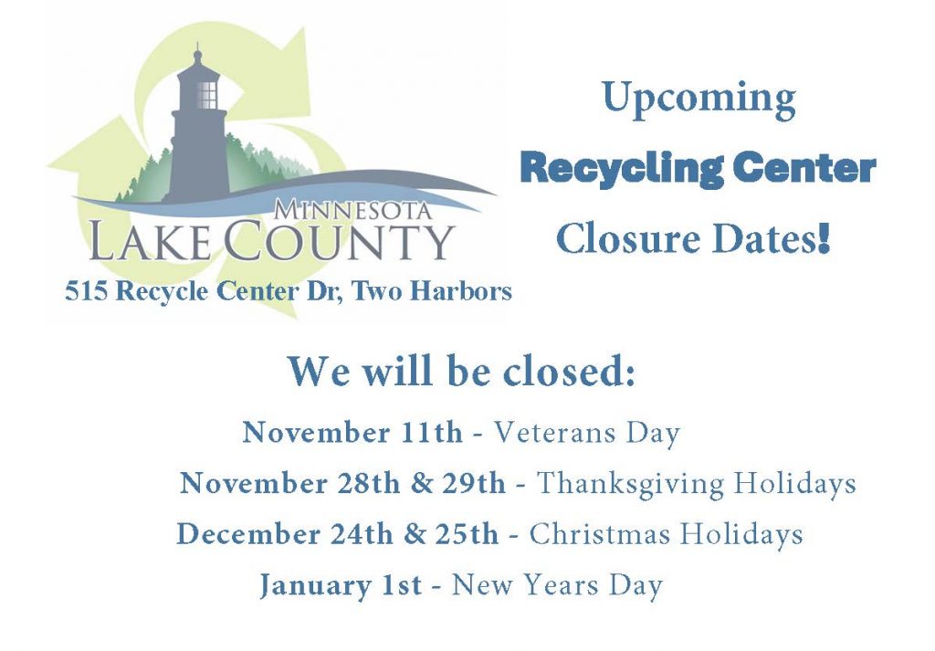
Lake County Recycling Center
Location: 515 Recycle Center Drive
Hours: Monday–Friday, 9:00 a.m.–3:00 p.m.
Accepted materials:
- Appliances
- Electronics
- Tires
- Household Hazardous Waste (HHW)
Lake County Demolition Landfill (Established Sites)
Location: West Castle Danger Road
Hours: Tuesday and Thursday, 10:00 a.m.–5:00 p.m.
Accepted materials:
- Scrap metal
- Concrete
- Small amounts of burned or green brush
- No root balls
- No trunks larger than 12 inches in diameter
Temporary Burned Vegetation Disposal Site
Location: Field across from the County Forestry Office, 419 Airport Road
Hours: Open 24 hours a day, 7 days a week
Accepted Materials
- Burned vegetation debris only
Not Accepted
The following materials must be taken to the appropriate disposal locations listed above:
- Burned building materials
- Demolition debris
- Household waste
- Appliances
- Metal
- Concrete
- Ash
- Any other non-vegetative fire debris
Temporary Burned Vegetation Disposal Site Map
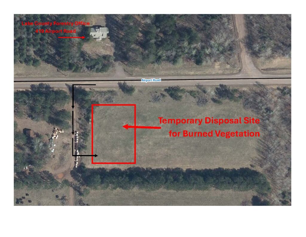
This site is dedicated exclusively to burned vegetation debris from properties impacted by the Stewart Trail Fire. Please follow all posted signs when entering and using the site.
The site will be monitored. If unauthorized materials are deposited, Lake County may restrict access or temporarily close the site.
Please check the County website for updates, as the site may close temporarily during significant rainfall or other conditions that affect safe access and operations.
Information for Commercial Contractors
Commercial contractors hauling burned vegetation debris on behalf of impacted property owners must contact Environmental Services at 218-834-8304 before delivering material.
Please provide:
- The property location where the debris originated
- The estimated volume of material
- The anticipated hauling schedule
Thank you for your cooperation as Lake County works to support safe and efficient wildfire recovery efforts.
Stewart Trail Fire update
Tuesday, May 26, 2026
Emergency Manager- Warren LaPlante
Lake County will host a Community Outreach Event for property owners whose property was damaged by the Stewart Trail Fire. This includes, but is not limited to, damage involving homes or other structures, septic systems, and burned or damaged trees.
Date: May 28, 2026
Time: Doors open at 5:00 p.m. and close at 7:00 p.m.
Location: Sonju Arena
Address: 301 8th Ave, Two Harbors, MN
Agencies and Organizations Available
Lake County Departments/Offices
- Public Health
- Planning and Environmental Services
- Recorder’s Office
- Auditor’s Office
- Veterans Service Office
- Emergency Management
State and Community Partners
- Minnesota DNR Forestry and Restoration
- Minnesota Homeland Security and Emergency Management
- Minnesota Department of Commerce (Insurance Regulation)
- United Way
- American Red Cross
- Two Harbors Food Shelf
- Justice North (Nonprofit Legal Support)
Property owners who are unable to attend the event may direct questions to:
Email: StewartTrailFireRecovery@lakecountymn.gov
Phone: 218-225-1712 (voicemail only)
Please share this information with neighbors and others whose property may have been impacted by the fire.
Thank you.
Stewart Trail Fire update
Wednesday, May 20, 2026 10:20 AM
Emergency Manager- Warren LaPlante
Supporting Families Affected by the Stewart Trail Fire
DONATING MONEY https://hlunitedway.org/resources/wildfire-resources/
Lake County is partnering with Head of the Lakes United Way to receive and distribute financial donations supporting individuals and families affected by the fire.
Head of the Lakes United Way will serve as the fiscal agent for donated funds and will administer assistance in a fair and transparent manner. All individuals and families affected by the fire will be eligible to apply for assistance.
Head of the Lakes United Way is not charging administrative fees related to this effort.
Donate by June 30 to support families. Donations made after June 30th will be designated to programs supporting community members in Lake County.
DONATING FOOD
Community members wishing to support local food assistance efforts are encouraged to donate food or financial contributions to the Two Harbors Food Shelf.
For large food donations, please call ahead to confirm storage capacity and delivery arrangements: 218-391-8191
DONATING OTHER ITEMS
At this time, specific needs for donated physical items, such as clothing, household goods and furniture, have not yet been identified. Community members are encouraged to continue supporting local charitable organizations through their regular donation channels.
Thank you for supporting those affected by the Stewart Trail Fire.
Stewart Trail Fire update
Tuesday, May 19, 2026 12:00 PM
Emergency Manager- Warren LaPlante
All evacuation zones related to the Stewart Trail Fire have been lifted, and the fire is now reported as 100% contained. Fire personnel will continue monitoring and mop-up operations within the fire area to address any remaining hotspots and ensure public safety.
Highway 61 has fully reopened to traffic, and all other county roads previously closed in association with the fire are now open. Motorists are asked to use caution while traveling through the area and remain alert for firefighters, emergency personnel, heavy equipment, and crews that may still be working along roadways and within the fire area.
Residents and property owners may now return to their homes and properties. Individuals returning to evacuated areas should continue to exercise caution, as fire personnel may still be operating in and around affected locations.
The Lake County Sheriff’s Office would like to thank residents, partner agencies, firefighters, emergency personnel, volunteers, and the public for their patience, cooperation, and support throughout this incident. The coordinated response and support from the community played an important role in protecting lives and property during the Stewart Trail Fire.
Stewart Trail Fire update
Sunday, May 18, 2026 10:00 AM
Emergency Manager- Warren LaPlante
Property owners within the evacuation area between Stewart River and the Silver Cliff Tunnel will have an opportunity to participate in escorted access to their properties today between 2:00 p.m. and 5:00 p.m.
Property owners must provide proof of residency or property ownership at check-in prior to entry. Acceptable documentation may include:
• Driver’s license with matching address
• Property tax statement
• Utility bill
• Other official documentation showing ownership or residency
Check-in will begin at 1:30 p.m. at the Betty’s Pies parking lot staging area, located at 1633 Highway 61, Two Harbors.
The final escorted entry into the evacuation area will depart at 4:00 p.m.
Escorted access will be coordinated by emergency personnel, and all participants must follow instructions from law enforcement and fire officials while in the area.
A Lake County Emergency Alert with this information will be sent to impacted individuals who are signed up for the Lake County emergency alert system. Residents and property owners who wish to receive future emergency notifications can register through the Lake County website.
Please note that conditions may change based on fire activity and public safety concerns.
If any property owners have questions regarding the escorted access process, please contact Chief Deputy Sheriff Tim Luoma at 218-834-8387. However, if your questions can wait until check-in, that would be preferable to help keep phone lines available for emergency operations.
Please visit the Lake County website for continued updates on the fire.
Stewart Trail
Publication Type: News – 05/18/2026 – 09:10
Size: 355 acres Origin: 3 miles north of Two Harbors, Minnesota County: Lake Start Date: May 15, 2026
Cause: Power Line Containment: 62% Structures Lost: 34, including 8 primary and 26 outbuildings
Total Personnel: 77
Today’s Highlight: Firefighters made notable progress securing containment lines and reducing fire activity within the interior fire perimeter. Firefighters acted quickly to knock down one small flare-up deep within the perimeter created by shifting winds. Due to increased containment and successful suppression efforts, evacuation zones have been reduced in areas where threats to public safety have diminished.
Operations: Firefighters have been working tirelessly to assess and strengthen control lines, mopping up at least 125 feet inside southern and western side perimeter and 60 feet inside the eastern perimeter. Flare up areas will continue to be patrolled and monitored. Structure teams completed mopping up around structures, creating protective buffers of 200 feet. Tracked vehicles and crews monitored the integrity of the dozer lines, ensuring the line held up to shifting winds. Overnight, two tracked vehicles and two engines patrolled the perimeter and all structures for flare-ups and hot spots. Firefighters gridded and patrolled the containment line before the rain started.
Planned Activity: Firefighters will continue to patrol and grid, systematically searching within the interior fire area for pockets of heat to be extinguished. Efforts will continue on securing and improving fire lines with hose lays on northern edge and mopping from the perimeter to interior at least 60 feet. Mop up includes checking for lingering heat, wetting down hot spots, extinguishing smoldering stumps, roots, and debris, and removing hazardous snags.
A temporary flight restriction (TFR) is in place. A TFR restricts aircraft from entering the designated area to ensure safety during firefighting operations. Do not fly unauthorized drones near the fire. Remember – If you fly, we can’t!
Closures: Due to impacts from firefighting resources, U.S. Highway 61 is closed between the Stewart River and the Silver Cliff Tunnel. A detour remains between Silver Bay to Two Harbors for those who need to travel around the area. For more information, people can visit http://511mn.org for updates from MNDOT.
The public is asked to follow the detour around Highway 61 and stay out of the closure area for their safety.
Evacuations: Lake County has reduced portions of the evacuation zone, and the Ready, Set, Go notification plan remains in effect. Current evacuation information can be referenced on the Lake County Fire Evacuation | Lake County Atlas Parcel Viewer.
Weather: Today, temperatures in the high 40’s, with northeasterly winds in the morning. Relative humidity up to 80%. Northeasterly winds increase to 6-14mph this evening, gusting to 25mph throughout the night. Precipitation potential increases throughout the evening, with a slight chance of thunderstorms tonight.
Stewart Trail Fire update
Sunday, May 17, 2026 3:50 PM
Emergency Manager- Warren LaPlante
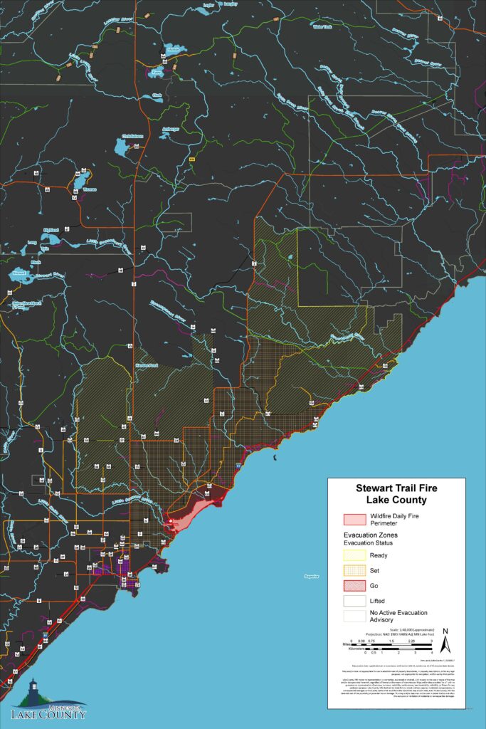
The Lake County Sheriff’s Office, in coordination with the Minnesota Incident Command System (MNICS) team and the Lake County Emergency Manager, has reduced portions of the evacuation zone related to the Stewart Trail Fire.
The updated evacuation map is available on the Lake County website, and a direct link is provided below. Changes to the evacuation area were made based on the current size, status, and behavior of the fire.
Residents are encouraged to carefully review the updated map to determine the current status of their area. Locations that are no longer within the active evacuation zone have been moved to “SET” status. Residents in these areas should remain prepared to evacuate if conditions change.
The Highway 61 detour remains in effect at this time. Motorists are asked to continue following posted detour routes and avoid the fire area to allow emergency personnel to operate safely.
However, portions of Highway 61will be reopened for local traffic returning to homes in areas that were previously under evacuation orders. Again, Highway 61 will remain closed to through traffic between the Stewart River and the Silver Cliff Tunnel.
Follow this link for updated Evacuation Zones:
https://experience.arcgis.com/experience/10688a627618414fa96159e8f70cba3c/page/Fire-Evacuation
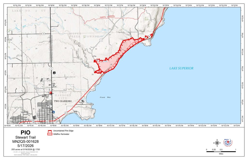
Stewart Trail Update
Sunday, May 17, 2026 12:15PM
MNICS Team A, Incident Commander Mike Hill
Online: https://inciweb.wildfire.gov/incident-information/mnmns-stewart-trail
Fire Information Line: 218-216-6884, 8:00 AM – 8:00 PM
Email: 2026.StewartTrail@firenet.gov
Facebook: https://www.facebook.com/mnics.org
Stewart Trail Fire Quick Facts
Size: 355 acres Origin: 3 miles north of Two Harbors, Minnesota County: Lake Start Date: May 15, 2026
Cause: Under Investigation Containment: 30% Structures Lost: 34, including 8 primary and 26 outbuildings
Total Personnel: 77
Today’s Highlight: Firefighters quickly responded with aircraft and ground crews to a spot fire along the northern perimeter, limiting fire spread even with the high winds and increased fire danger yesterday afternoon.
Operations: Firefighters assessed and strengthened the control lines. This included creating a Two-blade wide dozer line along the western side and cold trailing around the southern hand line, which means they checked for heat and wet down the area. Firefighters worked to contain a spot fire on the northeastern corner of the fire. Numerous aircraft provided water drops. Firefighters were able to get a better assessment of the fire size, and the acreage has been updated to 355 acres. Local fire departments worked on structure protection by mopping up to remove any hot spots within 50 feet around each structure. Crews continued containment and monitoring overnight, watching for flare-ups and areas of heat throughout the entire area.
Planned Activity: Crews continue to strengthen the dozer line and add hose line to areas along the northern perimeter. Structure protection will continue, and crews will increase the area around structures by doing mop-up and removing hot spots 100 feet or more around each structure.
Aircraft will continue to provide assistance with water and fire-retardant drops. A temporary flight restriction (TFR) is in place. A TFR restricts aircraft from entering the designated area to ensure safety during firefighting operations. Do not fly unauthorized drones near the Stewart Trail Fire. Remember – If you fly, we can’t!
Closures: Due to impacts from heavy smoke and firefighting resources, U.S. Highway 61 is closed at County Highway 2 in Two Harbors and at County Highway 106 (West Castle Danger Road) in Castle Danger, Minnesota. A detour has been set up from Silver Bay to Two Harbors for those who need to travel around the area. For more information, people can visit http://511mn.org for updates from MNDOT.
The public is asked to follow the detour around Highway 61 and stay out of the closure area for their safety.
Evacuations: Lake County has implemented the Ready, Set, Go notification plan. Current evacuation information can be referenced on the Lake County Fire Evacuation | Lake County Atlas Parcel Viewer.
Weather: Today, temperatures will be in the upper 40s. The humidity is higher today, around 58 percent. Winds shift to easterly today and will increase with speeds around 8 -17 mph in the morning and 18-21 with wind gusts of 30-35 late afternoon. Rain showers and storms are predicted to bring ¾ – 1 inch of precipitation late afternoon.

Stewart Trail Fire update
Sunday, May 17, 2026 9:40 AM
Emergency Manager- Warren LaPlante
As of this morning, the fire has remained within the same footprint as yesterday. Conditions continue to be monitored closely. Fire crews continue structural protection efforts, and firefighters remain actively engaged in containment operations throughout the incident area.
At this time, there are no changes to evacuation zones. For public safety, all residences and properties within the evacuation zone remain closed to public access. Re-entry is prohibited until further notice
.If you have questions regarding your property within the evacuation zone, please call the MNICS Public Information line at 218-216-6884 and leave your name and phone number. A coordinated response will be provided as information becomes available.
The Sheriff’s Office is working to contact all property owners whose structures sustained damage. During last evening’s press conference, the Lake County Sheriff reported that 34 structures were damaged, including 8 primary residences.
The shelter at Sonju Arena has been closed at this time. Lake County Public Health remains prepared to reopen shelter operations if conditions warrant it.
Stewart Trail Fire update
Saturday, May 16, 2026 7:45 PM
Link to Press Conference Here: Facebook Live Stream
Stewart Trail Fire update
Saturday, May 16, 2026 2:30 PM
Emergency Manager- Warren LaPlante
As of early this afternoon, the fire remained within its current footprint. Conditions continue to be monitored closely as we enter the hottest part of the day and winds remain active. Fire crews are continuing structural protection efforts, and firefighters remain engaged in suppression operations throughout the incident area.
At this time, there are no changes to evacuation zones. For public safety, all residences and properties within the evacuation zone remain closed to public access. Re-entry is prohibited until further notice.
Damage assessment is ongoing. We will provide more information when its available.
To View Evacuation Zones, follow this link: https://experience.arcgis.com/experience/10688a627618414fa96159e8f70cba3c/page/Fire-Evacuation
Stewart Trail Fire update
Saturday, May 16, 2026 10:47 AM
Emergency Manager- Warren LaPlante
Firefighters, including local fire departments from around the northland, battled the fire overnight focusing on structural protection and holding the line. Overnight, firefighters were able to get a better assessment of the fire size, and the acreage has been updated to 376 acres.
An initial Evacuation Point, which has turned into a shelter, was established at the Sonju Arena by Lake County Public Health. Red Cross assisted overnight and St Louis County provided informational support.
This morning at 06:00 a.m. a Type III IMT assumed command of the fire situation in Unified Command with Two Harbors Fire Department and Lake County Sheriff.
Lake County has implemented the Ready, Set, Go notification plan. Evacuation zones have been initiated, and the Shirreffs Office went door-to-door in the immediate hazard zone. The evacuation zones map can be found on the Lake County website by clicking on the “Lake County Mapping and Online Parcel Mapping” which is located on the main page, then clicking on the bottom right tab of the map titled fire evacuation.
Due to impacts from heavy smoke and firefighting resources, U.S. Highway 61 is closed at County Highway 2 in Two Harbors and at County Highway 106 (West Castle Danger Road) in Castle Danger, Minnesota. A detour has been set up from Silver Bay to Two Harbors for those who need to travel around the area. For more information, people can visit http://511mn.org for MNDOT updates.
The public is asked to follow the detour around Highway 61 and stay out of the closure area for their safety.
Please visit the Lake County website for continued updates on the fire.
To View Evacuation Zones, follow this link: https://experience.arcgis.com/experience/10688a627618414fa96159e8f70cba3c/page/Fire-Evacuation
Spring Road Load Restrictions Update
Spring Load Restrictions for County highway, roads, and Unorganized Territory (UT) roads will be lifted beginning Friday, May 14, except on the following list of roads:
- Cramer Road (CSAH 7, CSAH 8, and CR 705)
- Highway 3 (CSAH 3)
- Gun Club Road (CSAH 24)
- Fors Road (CR 301)
- Drummond Grade (CR 131)
- Old Drummond Road (UT 10)
- Westover Road (UT 34)
- Moen Road (CR 123)
- Highland Lake Road (UT 47)
We expect the remaining restrictions to be lifted before June.
Please take note that the legal load restriction is governed by the signs posted – if the lost restriction sign is posted, the load restriction is in place.
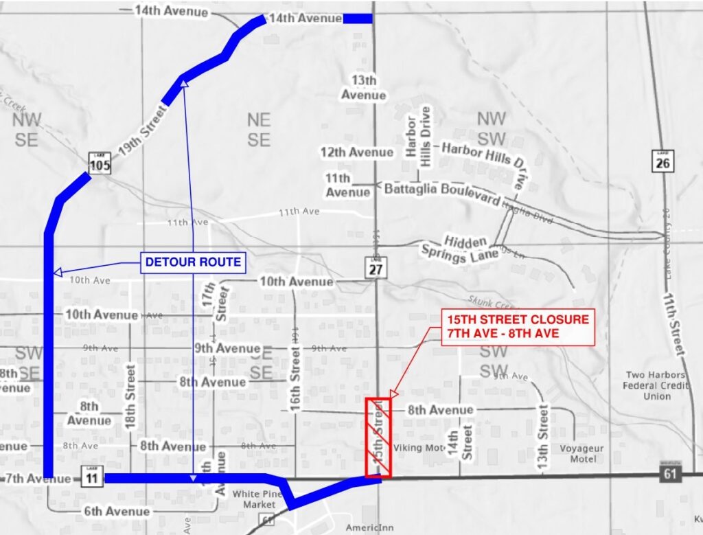
15th Street, Two Harbors – Planned Closure Begins Week of May 18
NOTICE
15th Street (CSAH 27) will be closed to traffic between 7th Avenue (Hwy 61) and 8th Avenue, including the intersection of 15th Street and 8th Avenue (see image attached).
When
Beginning: Week of May 18
Ending: July 3 (estimated)
Purpose
The closure is necessary for the City of Two Harbors and their contractor to complete improvements on city owned water and natural gas systems.
Traffic Impacts
A detour route will be posted on 7th Avenue (CSAH 11), 19th Street, and 14th Avenue (CR 105). 15th Street will remain open to residents between 9th Avenue and 15th Avenue. Access for residents with driveways between 7th Avenue and 8th Avenue will be coordinated with project personnel.
Please contact the City of Two Harbors with any project related questions or concerns.
Airport Road (CR 111) – Planned Closure Begins May 18
NOTICE
Lake County Highway Department will be closing Airport Road (County Road 111) to through traffic between Waldo Road (County Road 27) and Highway 2 (see image below).
When
Beginning: Monday, May 18, 6:00 AM
Ending: Friday, May 22, 7:00 PM (anticipated)
Why
This closure has been requested by CN rail to facilitate upgrading the west railroad crossing on Airport Road. The tracks and rail crossing surface will be removed and will not be open to highway traffic.
Residential Access: The road will be open to residents and local traffic on either side of the rail crossing closure.

Notice of Amendments to the Lake County Subdivision Ordinance #9 and Land Use Ordinance #12
Date: May 5, 2026
FOR IMMEDIATE RELEASE
Contact: Lake County Environmental Services Department, planningandzoning@co.lake.mn.us or 218-834-8441
On April 28, 2026, the Lake County Board of Commissioners approved by resolution the adoption of amendments to the Lake County Subdivision Ordinance #9 and Land Use Ordinance #12. The adopted ordinances will go into effect on May 8, 2026.
The County Board resolution and the ordinance amendments, are located below:
Resolution for Amendments to Land Use Ordinance #12 and Subdivision Ordinance #9
Advertisement for Bids, Highway Improvement Project
SAP 038-594-002 Lighthouse Point Road Street & Utility Improvements
Project Location: Lighthouse Point Road, Agate Bay Public Water Access to 1st Avenue – City of Two Harbors
Work Type: Grading, Bituminous Surfacing, ADA Improvements, Storm Sewer, Municipal Utilities
Project Type: Urban Reconstruction
Construction End Date: October 2, 2026
Link to One Office Page: https://mn-co-lake.app.rtvision.com/oneoffice/planning/contract?contract=116
Advertisement for Bids, Highway Improvement Project
Project Location: New Tomahawk Road (CSAH 34) over Stony River
Work Type: Bridge Rehabilitation
Project Type: Bridge Rehabilitation
Anticipated Construction Start Date: July 6, 2026
Final Completion Date: September 19, 2026
Link to One Office Page: https://mn-co-lake.app.rtvision.com/oneoffice/planning/contract?contract=113
Public Hearing Notice
NOTICE OF PUBLIC HEARING REGARDING AMENDMENTS TO THE LAKE COUNTY LAND USE ORDINANCE # 12 & LAKE COUNTY SUBDIVISION ORDINANCE #9
Notice is hereby given that the Lake County Planning Commission will conduct a public hearing on Monday, April 20, 2026, at 6:00 PM in the Law Enforcement Center, 613 Third Avenue, Two Harbors, Minnesota, to consider proposed amendments to Lake County Land Use Ordinance #12 and Lake County Subdivision Ordinance #9. All interested persons are invited to attend the public hearing to provide input. Interested persons may submit written comments via email message before 4:30 P.M. Thursday, April 16, 2026 to Tanya.feldkamp@co.lake.mn.us or to the Lake County Environmental Services Department, 601 Third Avenue, Two Harbors, MN 55616, prior to the hearing.
Severe Weather Awareness Week is April 13–17, 2026
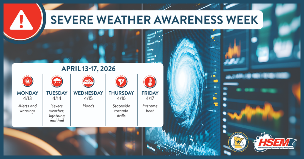
Lake County in conjunction with MN HSEM (Homeland Security and Emergency Management) and the NWS (National Weather Service) sponsor Severe Weather Awareness Week across Minnesota.
As we close out of winter, this is a great time to refresh, remind, and educate everyone on the seasonal severe weather threats and how to avoid them, along with protecting yourself, family, and friends. This is also a great time to create and practice an emergency plan and build a preparedness kit.
During this week, each day will have the following focus topics:
- Monday: Alerts and Warnings
- Tuesday: Severe Weather, Lightning and Hail
- Wednesday: Floods
- Thursday: Tornadoes (with statewide tornado drills)
- Friday: Extreme Heat
Across Minnesota, the 2026 statewide tornado drills are scheduled for Thursday, April 16 at 1:45 p.m. and 6:45 p.m. CDT.
Please take a few moments to visit the following link for additional severe weather preparedness information at Severe Weather Awareness Week.
To learn more about specific Lake County emergency preparedness opportunities, please come to visit us on April 26th for “Survive This! Lake County Emergency Resilience” at the Two Harbors High School from 1-3 p.m.
New Lake County Wildfire Evacuation Zones
Lake County is rolling out new wildfire evacuation zones and we are encouraging all residents, businesses, and property owners to become familiar with the updated zones. As an improvement to protecting our residents this effort is directly related to last years Camphouse Fire.
New zones can be found at: Fire Evacuation | Lake County Atlas Parcel Viewer NEW
What has changed: The zone sizes have been dramatically reduced allowing us to provide for a better readiness state through our mass notification and GIS systems. The previous zones were so large that realistically there could be all evacuation three stages in one zone, thus it didn’t provide a true evacuation readiness state for those closest to the fire hazard.
What has not changed: The three evacuation stages: READY, SET, and GO.
READY means “there is a potential for evacuation”
SET means “be prepared to evaluate in a moments notice”
GO means “evacuation immediately”
Additional information on wildfire readiness and Firewise programs:
- Wildfire Evacuation Checklist (fema.gov):
https://www.usfa.fema.gov/downloads/pdf/publications/wildfire-evacuation-checklist.pdf - Ready, Set, Go! – Ready for Wildfire:
https://www.readyforwildfire.org/prepare-for-wildfire/ready-set-go/ - DNR’s fire danger and burning restrictions website:
https://www.dnr.state.mn.us/forestry/fire/firerating_restrictions.html
If you have any questions, please contact Lake County Emergency Management, Warren LaPlante, at email: warren.laplante@co.lake.mn.us.
Notice of Amendments to the Lake County Cannabis Ordinance #29
Date: March 31, 2026
FOR IMMEDIATE RELEASE
Contact: Lake County Environmental Services Department, planningandzoning@co.lake.mn.us or 218-834-8325
On March 24, 2026, the Lake County Board of Commissioners approved by resolution the adoption of amendments to the Lake County Cannabis Ordinance #29. The adopted ordinance will go into effect on April 3, 2026.
Please review the County Board resolution and the ordinance amendments attached to this announcement.
Resolution for Amendments to Lake County Cannabis Ordinance #29
Weather Advisory – Friday, March 13
Lake County offices plan to remain open on Friday, March 13. Most departments will be operating with reduced staff due to the expected weather and road conditions. If you have county business to conduct, please contact the appropriate department before traveling. Residents are encouraged to delay arriving until weather conditions improve and roads have been cleared, if possible. Thank you for your patience and understanding.
Lake County Property Notices Arriving Soon
Lake County Property Notices Arriving Soon
Lake County property notices will be arriving in your mailbox soon. What to expect: your 2026 Property Tax Statement for Taxes Payable in 2026 and your 2026 Valuation Notice for Taxes Payable in 2027. Notices are mailed together in the same envelope. Be sure to review each notice for your property.
2026 property tax payments are due May 15 and October 15 for most properties. Visit the county website or scan the QR code below to see updated payment options.
2026 Valuation Notices contain your properties classification and estimated market value for your taxes in 2027. The time to review this information is now. Contact your assessor with questions or concerns. The Notice lists meeting dates and information to discuss or appeal your value and classification.
The property tax cycle in Minnesota follows three steps:
Step 1: Valuation and Classification Notice (March). The Assessor determines the estimated market value and classification of each property for the following year’s property taxes. Property owners are provided with an opportunity to review information and attend local or county board of appeal meetings to discuss or appeal their value and classification. Assessments are final after the meetings and appeal process is complete.
Step 2: Proposed Tax Notice (November). Local taxing districts set their budgets for the following year and propose their needed tax levy. Based upon the assessment provided by the assessor and proposed levies, an estimate of next year’s tax is sent to property owners. Public budget meetings are held for residents to provide input on proposed budget and levies. Final levies are set after public meetings are held.
Step 3: Property Tax Statement (March). Property taxes are calculated using the final assessment and levies. A statement is sent to each property owner showing the amount and dates property tax is due.
State law provides the form and content of each property notice, with a box in the upper right corner indicating the notice’s step in the tax cycle.
Resources for property tax information:
- Lake County website: www.co.lake.mn.us
- MN Department of Revenue website:
www.revenue.state.mn.us/understanding-property-tax - Lake County Auditor’s Office: 218-834-8315

The Native Plant Sale is now taking orders!
Native plant kits are curated to take the guesswork out of selection. Presale ends on May 17th and pick up will be at Shoreview Natives on June 6th. Find all the details and order online at www.shoreviewnatives.com/lakeswcdplantsale-1
Update 1: Lake County Emergency Alert System Update
Over the past few days, we have received several great questions and would like to share the following.
Please stay tuned here for all the latest updates and information regarding this project.
What have we completed already: Over the weekend, we have completed a few system configuration updates and working on many more. Some of the most important changes include detailing system grouping/types (residential, business, etc.) and have also begun organizing personal accounts into some of those groups/types. This effort will greatly enhance our community alerting for those most impacted by an incident.
Why is this important! There are thousands of individual accounts in the Lake County Emergency Alerts System, and we want to ensure that we have the right information and grouping types to ensure we are prioritizing those most impacted by an event, especially for those life safety incidents.
What’s Next: We will continue to review and update record type configurations (residential, business, etc), along with organizing individual accounts. We will also be updating the portal registration directions to clarify the information we are asking for if not included in a drop box, such as home, business, cabin, property, etc. The next step/phase after that, we will be asking everyone with an account(s) to log in to review, validate, and update their contact information. This will include reviewing for duplicate accounts and encouraging separate “static locations” for respective residential and business purposes.
To register or to review your current profile, you may get there from several directions.
-There is a link on the main website, just above this section,
-There is a link under the Emergency Management Department website page, or
-Cut and paste this link into your browser: https://member.everbridge.net/453003085619442/login
I ask those that are newly registering, once logged in to please fill in all informational blocks as there has already have been system updates; or if you already have an account, please log in to review, validate, and update any contact information that has changed, along with the new informational blocks that have been added.
We have also received several additional questions over the last week, and I would like to take a few moments to answer a few:
- Lake County is and will continue to reach out to municipalizes ensuring, we as a team, are informing the citizens and businesses within our county, as appropriate, on events impacting life-safety, such as severe weather/storms, power outages, wildfires, and need for evacuations or sheltering. Lake County will also be kicking off several additional large projects, the County Emergency Operations Plan (EOP) and Community Wildfire Prevention Plan (CWPP) updates and rewrites. Both of these plans work hand-in-hand and will tie our county-wide communities together for support and response.
- Everbridge is the same platform the county has used in the past. We are updating the system configurations and contact information to better communicate and conduct community outreach during some of the events and incidents listed above. This is why it is important for all of us to do our part to update and maintain your personal contact information. So, if and when that day occurs, we can send “the right message, to the right people, at the right time”.
Thank you,
Warren LaPlante
Lake County Emergency Management, Director
Notice of Public Hearing
NOTICE OF PUBLIC HEARING REGARDING AMENDMENTS TO THE LAKE COUNTY LAND USE ORDINANCE # 12, LAKE COUNTY CANNABIS ORDINANCE #29, & LAKE COUNTY SUBDIVISION ORDINANCE #9
Notice is hereby given that the Lake County Planning Commission will conduct a public hearing on Monday, March 16, 2026, at 5:30 PM in the Law Enforcement Center, 613 Third Avenue, Two Harbors, Minnesota, to consider proposed amendments to Lake County Land Use Ordinance #12, Lake County Cannabis Ordinance #29, and Lake County Subdivision Ordinance #9. All interested persons are invited to attend the public hearing to provide input. Interested persons may submit written comments via email message before 4:30 P.M. Thursday, March 12, 2026 to Alexandra.Campbell@co.lake.mn.us or to the Lake County Environmental Services Department, 601 Third Avenue, Two Harbors, MN 55616, prior to the hearing.
Cannabis Ordinance Changes.pdf
NOTICE OF PUBLIC COMMENT PERIOD ON USE OF FEDERAL FUNDS
Notice of intended use is hereby give by Lake County to use FY2024 – 2025 Title III funds under Public Law 119-58 “Security Rural Schools and Community Self-Determination Act” (reauthorized in 2025) through FY2028 to:
- carry out activities under the Firewise Communities Program to increase protection of people and property from wildfires
- reimburse the County for search and rescue and other emergency services performed on federal lands, including firefighting and law enforcement patrols
- cover training costs and equipment purchase directly related to emergency services described about, and
- develop and carry out Lake County Community Wildfire Protection Plan.
The intended use of this funding is open for public comment for a period of 45 days from the publication notice and will be on the Lake County Board of Commissioners agenda approximately 2 weeks upon public comment period closeout. Comments much be submitted in writing and received at the Commissioner’s Office, 616 Third Ave, Two Harbors, MN 55616 or the Emergency Management Office, 601 Third Ave, Two Harbors, MN 55616. For information, contact Warren LaPlante, Emergency management Director at 218-510-0624 (warren.laplante@co.lake.mn.us) or Matt Huddleston, Lake County Administrator at 218-834-8320 (matthew.huddleston@co.lake.mn.us).
Lake County Emergency Alert System Update
Lake County will be updating and verifying its emergency alert system in the coming months. The county uses a platform called Everbridge and its moto is to provide, “the right message, at the right time, to the right people.” When seconds count, the system delivers real-time alerts through text, phone, and/or email to provide critical information during an emergency. This information may include: the location of and respective emergency updates; if needed, evacuation orders and instructions; if determined, sheltering-in-place instructions; and where to stay tuned for additional information.
The Lake County Emergency Management department will conduct a multi-phase update including system configuration improvements, notification process reviews, participant (residential/business) verification, and annual testing. Progress updates and instructions will be shared through the county website and official social media.
Enrollment is optional but for public safety, residents and businesses are still strongly encouraged to register or update their information during this period.
Questions can be directed to Warren LaPlante, Emergency Management Director, at warren.laplante@co.lake.mn.us.
Photo of a lake shoreline with a dock and native flowers
Recording of Shoreline Workshop now available on YouTube!
Learn why natural shorelines are beneficial, how to assess shoreline health, ways to protect and restore your shoreline, and what assistance is available.
Beaver Bay: Boil Drinking Water Advisory
The city of Beaver Bay had experienced a water line break on 12 January and has implemented a boil drinking water advisory.
Please visit the Beaver Bay website for the latest advisory information and cancelation: https://www.beaverbaymn.com/
Lake County Emergency Management
Financial assistance to treat invasive species
We currently have funding available to help landowners address priority invasive plant species on their property!
Winter Hazard Awareness Week (November 17-21)
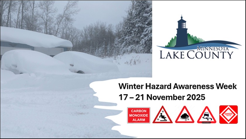
Winter is just around the corner and are you prepared?
November 17th to the 21st is Minnesota Winter Hazard Awareness Week. This is an opportunity to begin your and your family’s preparation for what will lie ahead: cold temperatures, windy days, icy roads, and slippery sidewalks.
Lake County Emergency Management, in partnership with Lake County’s Public Health, Sheriff’s Office, Highway Department, and the Safety Office, along with the Minnesota Department of Emergency Management and Public Safety have complied timely seasonal information to increase your awareness and preparation.
To find out more about specific topics, please visit the Lake County Website, Department of Emergency Management: https://www.co.lake.mn.us/emergency-management
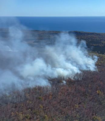
Final Crosby Fire Update (10/15/2025)
Final Crosby Fire Update (10/15/2025/13:30):
This will be Lake County’s final situation update.
The Crosby Fire has remained at approximately 300 acres for the last several days and approximately 95% contained. The fire location is still primarily within the George H. Crosby Manitou State Park.
MN DNR has determined the cause of the fire to be lighting.
The Superior Hiking Trail will open on Thursday, 16 Oct, 08:00 am.
On behalf of the county residents and staff, and our visitors, we would like to thank all the responders and support staff on doing a wonderful job to control the fire, protect our residents and their properties, along with our forests.
Lake County Emergency Management
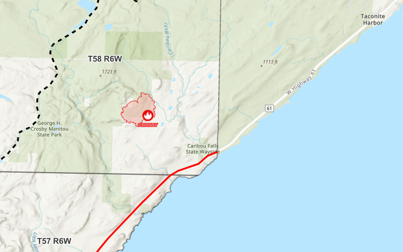
Crosby Fire Update (10/13/2025)
Crosby Fire Update (10/13/2025/9:00):
The Crosby Fire is approximately 300 acres and approximately 70% contained. The fire location is still primarily within the George H. Crosby Manitou State Park.
MN DNR has determined the cause of the fire to be lighting.
MN DNR remains lead agency with support from the US Forest Service. Lake County Sheriff’s Office and Emergency Management department are monitoring the situation and working with the MN DNR.
Based upon the location of the fire at this time, there are no immediate threats to residents or permanent residential structures.
We are asking for the public to stay clear of the area allowing our responders a safe environment to suppress the fire and for your personal safety.
Portion of the Superior Hiking Trail from the Caribou Falls State Wayside Rest along Minnesota State Highway 61 to the Lake County Road 7 (Cramer Road) access points remain closed. The remainder of the state park remains open
Please follow the situation through the Lake County website, both the Lake County and Lake County Sheriff’s Office Facebook sites, MN DNR, and the MNICs press release section. If the situation escalates, we will send out emergency notifications as appropriate through our county alerts program.
Lake County Emergency Management
Photo courtesy of the MN DNR.
Crosby Fire
Crosby Fire Update:
The Crosby Fire is approximately 50 acres within the George H. Crosby Manitou State Park. The park is a wilderness area with tough terrain.
MN DNR is lead agency with support from the US Forest Service. Lake County Sheriff’s Office and Emergency Management department are monitoring the situation and working with the MN DNR.
Based upon the location of the fire, there are no immediate threats to residents or permanent residential structures.
We are asking for the public to stay clear of the area allowing our responders a safe environment to suppress the fire and for your personal safety.
Please follow the situation through the Lake County website, both the Lake County and Lake County Sheriff’s Office Facebook sites, MN DNR, and the MINICs press release section. If the situation escalates, we will send out emergency notifications as appropriate through our county alerts program. Lake County Emergency Management
Notice of Tax-Forfeited Land Sale – Settlement Period Parcels
Lake County will be having an online auction at publicsurplus.com from 10:00 AM on Monday, November 3, 2025 through 1:00 PM on Wednesday, December 3, 2025.
Notice of Auction – Settlement.pdf

Street Closures Planned for Two Harbors Beginning Monday, 9/29
Northland Constructors will close 7th Street and Waterfront Drive at 6th Avenue in Two Harbors over the next 4-6 weeks. The tentative schedule for the closures follows: 7th Street Closure at 6th Avenue: Begin: Monday 9/29 End: Friday 10/17 Alternate Route: Waterfront Drive Waterfront Drive Closure at 6th Avenue: Begin Monday 10/20 End: Friday 10/31 Alternate Route: 7th Street & 5th Street Both streets will be closed at 6th Avenue but remain open to Local Traffic to the alleys and driveways on the north and south side of the 6th Avenue intersection. Work to be completed includes city utilities, storm sewer, new curb, sidewalk and pavement.
September is National Preparedness Month
Preparedness Starts at Home. September is National Preparedness Month and there is no better time than now to prepare yourself and family by taking a few steps to help your family, pets, neighbors, and communities.
The goal for preparedness begins with four key actions:
-Know the different types of emergencies you may encounter and what would be your response
-Make a family plan
-Build an emergency supply kit
-Get involved in your community by taking action to prepare for emergencies
When setting up your plan, consider any unique needs, where you live, where your family spends a lot of time (school, work, etc), do you have pets, routes of possible travel, how to evacuate from your home, do you take special medication, any other special needs.
Your plan should include:
-Family emergency plan(s) that includes important information, such as: contact information, medical providers/doctors, medications, insurance information, location to safeguard this information, communications plan
-Know where you could go before something happens, such as a meeting location(s) depending on the situation, how are you going to communicate with each other on your plan
-Have a home escape plan and meeting location in case of a home fire
-Pets are part of our family, include them in your family plan
–Build a go-kit. You kit should include enough supplies to support your family for several days: water, food, medicine, a comfort toy for your child, radio, flashlight, etc.
-When emergency strikes, have multiple ways to get alerts, include items such as a NOAA radio, National Weather Service (NWS) phone apps, local news links, the Lake County Emergency Alerts program (click here to register).
To assist you on your planning, please visit READY.GOV right now and follow the Lake County Emergency Management website (soon under re-development).
If you have any immediate questions, please contact Warren LaPlante, Lake County Emergency Management Director, email: warren.laplante@co.lake.mn.us
Lake County Property Tax Payment Reminder
Property Tax due dates are May 15 and October 15 of each year. (If the 15th is a Saturday or Sunday, taxes are due on the following Monday)
Lake County has a drop box available in front of the Law Enforcement Center at 613 3rd Ave. There is a sign on the drop box indicating that property tax payments are being accepted.
Taxpayers can view or print their current or delinquent tax statements at any time using the website parcelinfo.com.
Taxes can be paid in person, by mail, drop box or online.
Please see the Lake County Auditor’s webpage for details at co.lake.mn.us/auditor/.
Highway 2 Reopening to Traffic
Lake County Highway 2 between Forest Highway 11 (Lake County Road 15) and Minnesota Hwy 1 (MN 1) is scheduled to reopen to traffic beginning on Thursday, August 21.
Travelers can expect reduced travel lane and shoulder widths, and rough road conditions, with sections of unpaved road, grooved pavement surfaces, and active road construction work between the White Pine Picnic area near Upland Trail and the Greenwood Lake Public Water Access point (boat launch). Motorcycle travel is not recommended. During daylight hours, travelers can expect one-lane road conditions under traffic flagger control throughout the work zone. Delays of up to 15 minutes should be expected. Work is scheduled to continue through early October.
Please reduce speed and travel safely through the work zone and let’s make sure everyone, including our construction workers and onsite staff, gets home or to their destination safely.
Highway 2 Road Closure Update
KGM Contractors will be completing work on the new box culvert at Greenwood Creek this week and will be moving to Murphy Creek near Upland Trail beginning Monday, 7/28.
IMPORTANT: Access to Upland Trail/Whyte Road and to all points north along Highway 2 will need to be via MN Highway 1, starting Monday, 7/28. There will be no access across Murphy Creek, south of Upland Trail, beginning Monday 7/28. Highway 2 will be closed at the White Pine Picnic Area. Access across Greenwood Creek will be open.
Notice of Amendments to SSTS Ordinance
Notice of Amendments to the Lake County Subsurface Sewage Treatment System Ordinance #11
Date: June 25, 2025
FOR IMMEDIATE RELEASE
Contact: Lake County Environmental Services Department, planningandzoning@co.lake.mn.us or 218-834-8325
On June 24, 2025, The Lake County Board of Commissioners approved by resolution, adoption of amendments to the Lake County Subsurface Sewage Treatment System Ordinance #11. The adopted ordinance will go into effect on July 4, 2025.
Please review the County Board resolution and the ordinance amendments, which will be located at www.co.lake.mn.us and contact the Lake County Environmental Services Department if you have questions.
Resolution Approving Amendments to Subsurface Sewage Treatment System Ordinance #11, Section 101.A
Notice of Amendments to Land Use Ordinance
Notice of Amendments to the Lake County Comprehensive Plan and Land Use Ordinance #12
Date: June 25, 2025
FOR IMMEDIATE RELEASE
Contact: Lake County Environmental Services Department, planningandzoning@co.lake.mn.us or 218-834-8325
On June 24, 2025, The Lake County Board of Commissioners approved by resolution, adoption of amendments to the Lake County Comprehensive Plan and Land Use Ordinance #12. The adopted ordinance will go into effect on July 4, 2025.
Please review the County Board resolution and the ordinance amendments, which will be located at www.co.lake.mn.us and contact the Lake County Environmental Services Department if you have questions.
Resolution Approving Amendments to Land Use Ordinance #12, including Exhibit 1
Highway 2 Closure Information
CSAH 2 Reconditioning Project
Project #: SAP 038-602-036
Highway: CSAH 2 (Highway 2)
Location: Murphy Creek (near White Pine Picnic Area) to Greenwood Lake Public Water Access
Scope: Reconditioning (replace culverts, reclaim existing pavement and resurface)
Schedule: June 23, 2025 – October 4, 2025
Traffic Impacts: Highway 2 closure with posted detour – July thru mid August. Single lane closures with travel delays in late June and mid-August thru September
UPDATES and additional information can be found at the Highway 2 Reconditioning project information page.
Planning Commission hearing for Lake County Ordinance changes
The hearing will be held on June 16th, 2025 at 3PM.
2025 Spring Road Load Restrictions
The Lake County Highway Department will end spring load restrictions (SLR) on Monday, May 12, 2025 at 12:01 AM EXCEPT for the following roads:
| CR 131 Drummond Grade | CSAH 7 (Cramer Road) | CSAH 8 (Cramer Road) |
| CSAH 24 (Gun Club Road) | CR 301 (Fors Road) | CSAH 3 (Highway 3) |
Ending dates for spring load restrictions are variable and based on how weather is affecting roadway strength. The sign erected on the roadway governs the load limit in effect.
Lake County Property Tax Payment Reminder
Property Tax due dates are May 15 and October 15 of each year. (If the 15th is a Saturday or Sunday, taxes are due on the following Monday).
Lake County has a drop box available in front of the Law Enforcement Center at 613 3rd Ave. There is a sign on the drop box indicating that property tax payments are being accepted.
Taxpayers can view or print their current or delinquent tax statements at any time using the website parcelinfo.com.
Taxes can be paid in person, by mail, drop box or online.
Please see the Lake County Auditor’s webpage for details at co.lake.mn.us/auditor/.
Volunteer opportunity for Lake County Planning Commission or Board of Adjustment
The Lake County Board of Commissioners is seeking individuals interested in volunteering on the Lake County Planning Commission or Board of Adjustment. These commissions meet once per month and make decisions regarding land development and environmental issues. Applicants must reside in Lake County, but preferably outside any municipal corporate limits. Please contact the Lake County Environmental Services Department at the Lake County Courthouse, 601 Third Avenue, Two Harbors, MN 55616, email planningandzoning@co.lake.mn.us , or call 218-834-8325 for more information.
Please submit a resume or application by May 1, 2025.
Announcement on transportation project advertisement for bids
The Lake County Board of Commissioners has designated The Lake County, Minnesota Website as the official publication location for any transportation project advertisement for bids. Bid advertisements can be found at this link: Construction Projects – Lake County, MN
Document Alert
Attention Property Owners: There is a new document notification service available.

Notice of Public Hearing for proposed Lake County Cannabis Ordinance
Notice of Public Hearing
Lake County, Minnesota
Notice is hereby given that the Lake County Board of Commissioners will hold a Public Hearing on Tuesday, December 17, 2024, at 2:30 P.M. at the Lake County Service Center, Split Rock River Room, 616 Third Avenue, Two Harbors, Minnesota, 55616.
The purpose of the public hearing is to receive comments on a proposed Lake County Cannabis Ordinance.
Summary of the proposed Lake County Cannabis Ordinance:
- Prohibits public use of cannabis
- Limits registrations of cannabis retail operations
- Prohibits cannabis businesses within certain distances from schools, day care providers, residential treatment facilities and attractions within public parks
- Limits hours of operations
- Provides zoning framework for cannabis businesses and hemp businesses
- Provides regulations for cannabis events
- Establishes requirements on sale of low potency hemp
A draft of the proposed ordinance is available at the Lake County Service Center, Office of the County Administrator, 616 Third Avenue, Two Harbors, Minnesota, 55616. All persons interested are invited to attend the Public Hearing. Written comments may be submitted to clerk.board@co.lake.mn.us or by U.S. Postal Service mail to Lake County Service Center, Office of the County Administrator, 616 Third Avenue, Two Harbors, Minnesota, 55616
Public Comment Sought for Lake County’s Hazard Mitigation Plan
Lake County has completed an updated draft of its Hazard Mitigation Plan (HMP) and is now seeking public feedback. Like all Minnesota counties, Lake County is vulnerable to a variety of natural hazards such as tornadoes, windstorms, severe winter storms, flooding, drought, and extreme temperatures, which can threaten the loss of life and property in the county. Planning for natural disasters minimizes the impact of events that can cause vast economic loss and personal hardship.
U.S. Small Business Administration Disaster Loans
The Small Business Association offers low interest loans for homeowners and businesses that have been impacted by disasters. In June, Lake County saw widespread flooding that impacted many homeowners. To apply for an SBA loan, please call or register online.
Lake County Property Tax Payment Reminder
Property Tax due dates are May 15 and October 15 of each year. (If the 15th is a Saturday or Sunday, taxes are due on the following Monday).
Lake County has a drop-box available in front of the Law Enforcement Center at 613 3rd Ave. There is a sign on the drop box indicating that property tax payments are being accepted.
Taxpayers can view or print their current or delinquent tax statements at any time using the website parcelinfo.com.
Taxes can be paid in person, by mail, drop box or online.
Please see the Lake County Auditor’s webpage for details at co.lake.mn.us/auditor/.
Disaster Recovery Center to Open in Virginia
A FEMA/State Disaster Recovery Center will open Friday, August 16, 2024, to help residents kickstart
their recovery after the severe storms and flooding of June 16 – July 4.
Federal Disaster Declaration Expansion
After Request from Governor Walz, Federal Disaster Declaration Expanded to Include Individual Assistance for Minnesotans Impacted by Flooding
Governor Tim Walz today announced that Minnesotans in 19 counties working to recover from this year’s flooding can now request individual assistance from the Federal Emergency Management Agency (FEMA) to help recover from losses they suffered. The declaration will provide resources to reimburse individuals and communities for debris removal, emergency protective measures, and repair and replacement of damaged infrastructure.
The individual assessment declaration is the next step in the state’s ongoing dedication to assisting affected communities.
While individual assistance cannot compensate for all losses caused by a disaster, it is a significant step in helping people meet their basic needs and supplement disaster recovery efforts.
The following counties are currently part of the declaration: Blue Earth, Cook, Cottonwood, Faribault, Freeborn, Goodhue, Itasca, Jackson, Lake, Le Sueur, Mower, Nicollet, Nobles, Rice, Rock, St. Louis, Steele, Waseca, and Watonwan.
In the coming days, FEMA, in partnership with HSEM, will establish disaster recovery centers to assist people in navigating the process and house state agency representatives to ensure individuals and businesses understand all the programs that are available. More information on how to access these centers will be forthcoming from FEMA.
In the meantime, individuals in the declared counties are encouraged to create an application online by visiting disasterassistance.gov/. You can also call the FEMA Helpline at 800-621-3362. Specialists are available seven days a week from 7 a.m. to 11 p.m. ET.
For Lake County residents, the disaster recovery center will most likely be in Virginia, where individuals can apply for reimbursement or funds to repair damages. The dates and times of the center will be updated when more information is available. If you have any questions or concerns, please contact Matt Pollmann, Lake County Emergency Manager, at 773-844-6449.
Lake County PLSS (Public Land Survey System) Remonumentation Notice
Lake County is excited to start its Public Land Survey corner maintenance and restoration project. With the help of Bolton & Menk, we’re going to locate and/or establish the position of all the section corners in Townships 52-11 & 53-11.
Lake County PLSS Remonumentation 2024 Landowner Letter (pdf)
Press Release – Malberg Lake Rescue
Lake County Sheriff’s Office Media Release
June 7, 2024
Malberg Lake Rescue
On June 6, 2024, at 1546 hours (3:46 pm), Lake County Dispatch received a call from a female party whose husband was in the BWCA with 3 other men. She indicated that she received a call from Focus Point International stating that they had received an SOS from a locator from that group. Coordinates from the locator placed the group on Malberg Lake within the BWCA, and there was no information available as to the type of emergency that may be occurring due to the locator not having messaging capability.
Based on the limited information, the US Forest Service was contacted to see if a Beaver could fly in with a Lake County Deputy and medical personnel to check on the group. At approximately 1747 hours, initial contact was made with the group. The group indicated that a 69-year-old member of their group was last seen at 1130 that morning when he went for a walk and had not returned.
Based on the remote location and time of day, a ground search was planned utilizing Lake County Search and Rescue personnel, which would start the following morning.
The Minnesota State Patrol was requested and with the assistance of their fixed wing aircraft were able to locate the missing party some distance away from the location of the group. The missing party was actively trying to communicate with the aircraft.
The decision was made to activate the Minnesota Aviation Rescue Team (MART) through the Minnesota State Patrol to assist in rescuing the missing party.
At approximately 2342 the missing party was rescued and transported via helicopter to the Ely airport where he was checked out by medical personnel.
The Lake County Sheriff’s Office would like to thank the Minnesota State Patrol, US Forest Service, Minnesota Aviation Rescue Team and Ely Ambulance for their assistance.
Press Release – Basswood Lake water emergency
Lake County Sheriff’s Office Media Release
June 6, 2024
Basswood Lake, Boundary Waters Canoe Area, Water Emergency
On June 4, 2024 at 1536 hours (3:36 pm), Lake County Dispatch received a call of a Boy Scout group with an overturned canoe on Basswood Lake. Four juveniles and one adult male had made it to an island, while four more juveniles and another adult male were on the mainland. No injuries were reported at this point.
Ontario Provincial Police (OPP) notified Dispatch that they also had been contacted by the campers and advised them that rescue plans were in the works, and the group was advised to stay put. OPP advised that they would be on standby if their assistance was needed, but due to the weather they were unable to assist with any air assets.
Rescue units were dispatched and USFS was contacted for assistance. Due to the approaching storm front, it was decided that for the safety of all, rescue crews would go in to assist the following morning.
At 1759 hours (5:59 pm), OPP notified Dispatch that they had been in contact with the adult via Garmin and were advised that the campers had been rescued and they no longer needed assistance from law enforcement or rescue.
No additional information is available at this time.
Press Release – Bulen media release
Lake County Sheriff’s Office Media Release
June 6, 2024
A male was discovered deceased in the Baptism River on May 12th.
On May 12, 2024 at 1144 hours (11:44 am), Lake County Sheriff’s Office responded to a report of a body found in the Baptism River in Tettegouche State Park. At 1518 hours (3:18 pm) when Lake County Deputies and Rescue had retrieved the body from the river, the decedent’s identity was unknown.
On May 13, 2024 at approximately 1800 hours (6:00 pm), some clothing and a wallet, belonging to Zachery Bulen of Finland, were located at the base of Illgen Falls north of Tettegouche State Park. A positive identification was confirmed with fingerprints by the Minnesota BCA.
Agencies assisting the Lake County Sheriff’s Office during this incident were Lake County Rescue, Minnesota DNR, Tettegouche State Park, Silver Bay Police, and Minnesota Bureau of Criminal Apprehension (BCA).
At this time, a cause of death has not been determined and the incident is still being investigated.
Press Release – White Iron Lake drowning
Lake County Sheriff’s Office Press Release
May 28, 2024
A male was discovered deceased in White Iron Lake over the weekend.
On Sunday, May 26, 2024 at 1406 hours (2:06 pm), the Lake County Sheriff’s Office received a call from a party who had seen a body floating on the water on White Iron Lake.
At approximately 1437 hours (2:37 pm), Lake County Sheriff’s Office arrived on scene. Also responding to the scene were the U.S. Forest Service, DNR, U.S. Border Patrol, and Morse-Fall Lake Fire Dept. Contact was made with the reporting party who stated they had seen an unoccupied boat banging on the rocks and then noticed the body floating on the water.
Initial investigation did not indicate any accident had occurred and the victim was not wearing a lifejacket at the time of the incident.
The Medical Examiner Investigator preliminarily ruled it an accidental drowning and the incident is still an active investigation pending final results.
The victim has been identified as 54 year-old Duane Kreuger from St. Louis, Missouri.
2024 Spring Road Restrictions
The Lake County Highway Department will end spring load restrictions (SLR) on Monday, May 6, 2024 at 12:01 AM EXCEPT for the following roads:
| UT50 Murphy Lake Rd | UT51 Tikkanen Road | UT52 Kari Road | UT53 Rikala Road |
| UT54 Koski Road | UT55 Ahlgren Road | UT56 Etelainen/Rinne Road | UT 57 Grondahl Road |
| UT58 Kamarainen Road | UT59 Nelson Road | CR118 Toivonen Road |
Ending dates for spring load restrictions are variable and based on how weather is affecting roadway strength. The sign erected on the roadway governs the load limit in effect.
Lake County Property Tax Payment Reminder
Property Tax due dates are May 15 and October 15 of each year. (If the 15th is a Saturday or Sunday, taxes are due on the following Monday).
Lake County has a drop-box available in front of the Law Enforcement Center at 613 3rd Ave. There is a sign on the drop box indicating that property tax payments are being accepted.
Taxpayers can view or print their current or delinquent tax statements at any time using the website parcelinfo.com.
Taxes can be paid in person, by mail, drop box or online.
Please see the Lake County Auditor’s webpage for details at co.lake.mn.us/auditor/.