Stewart Trail Fire – 10:00 AM May 18 Update
Stewart Trail Fire update
Sunday, May 18, 2026 10:00 AM
Emergency Manager- Warren LaPlante
Property owners within the evacuation area between Stewart River and the Silver Cliff Tunnel will have an opportunity to participate in escorted access to their properties today between 2:00 p.m. and 5:00 p.m.
Property owners must provide proof of residency or property ownership at check-in prior to entry. Acceptable documentation may include:
• Driver’s license with matching address
• Property tax statement
• Utility bill
• Other official documentation showing ownership or residency
Check-in will begin at 1:30 p.m. at the Betty’s Pies parking lot staging area, located at 1633 Highway 61, Two Harbors.
The final escorted entry into the evacuation area will depart at 4:00 p.m.
Escorted access will be coordinated by emergency personnel, and all participants must follow instructions from law enforcement and fire officials while in the area.
A Lake County Emergency Alert with this information will be sent to impacted individuals who are signed up for the Lake County emergency alert system. Residents and property owners who wish to receive future emergency notifications can register through the Lake County website.
Please note that conditions may change based on fire activity and public safety concerns.
If any property owners have questions regarding the escorted access process, please contact Chief Deputy Sheriff Tim Luoma at 218-834-8387. However, if your questions can wait until check-in, that would be preferable to help keep phone lines available for emergency operations.
Please visit the Lake County website for continued updates on the fire.
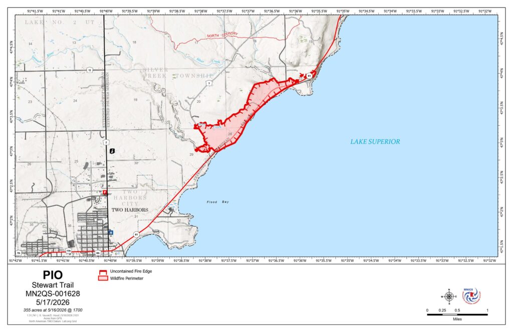
Stewart Trail
Publication Type: News – 05/18/2026 – 09:10
Size: 355 acres Origin: 3 miles north of Two Harbors, Minnesota County: Lake Start Date: May 15, 2026
Cause: Power Line Containment: 62% Structures Lost: 34, including 8 primary and 26 outbuildings
Total Personnel: 77
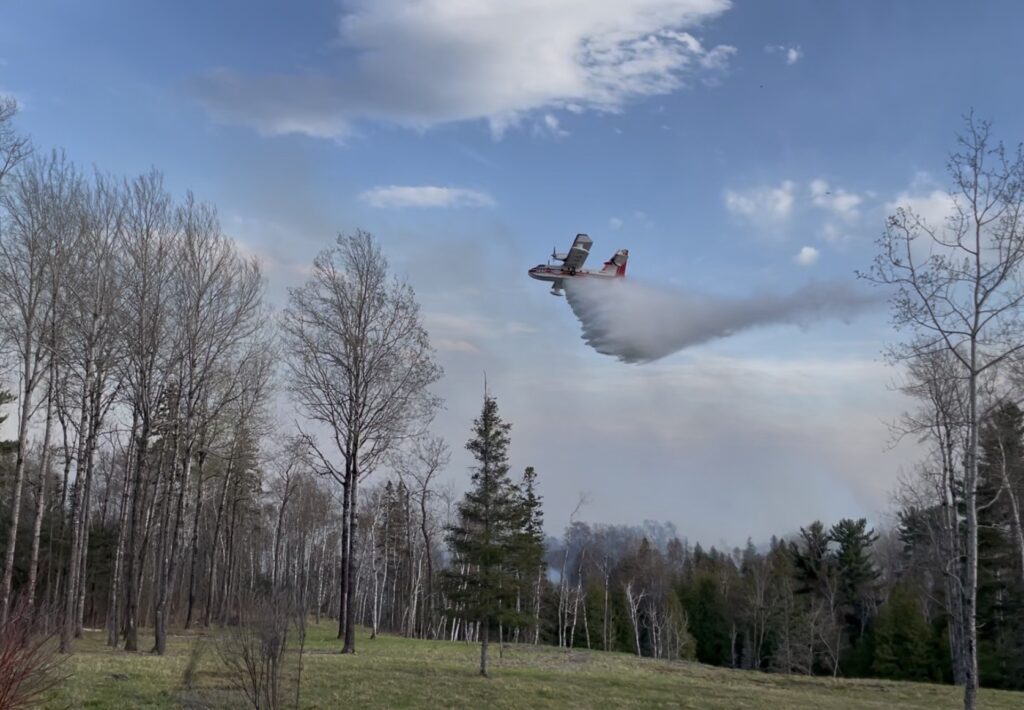
Today’s Highlight: Firefighters made notable progress securing containment lines and reducing fire activity within the interior fire perimeter. Firefighters acted quickly to knock down one small flare-up deep within the perimeter created by shifting winds. Due to increased containment and successful suppression efforts, evacuation zones have been reduced in areas where threats to public safety have diminished.
Operations: Firefighters have been working tirelessly to assess and strengthen control lines, mopping up at least 125 feet inside southern and western side perimeter and 60 feet inside the eastern perimeter. Flare up areas will continue to be patrolled and monitored. Structure teams completed mopping up around structures, creating protective buffers of 200 feet. Tracked vehicles and crews monitored the integrity of the dozer lines, ensuring the line held up to shifting winds. Overnight, two tracked vehicles and two engines patrolled the perimeter and all structures for flare-ups and hot spots. Firefighters gridded and patrolled the containment line before the rain started.
Planned Activity: Firefighters will continue to patrol and grid, systematically searching within the interior fire area for pockets of heat to be extinguished. Efforts will continue on securing and improving fire lines with hose lays on northern edge and mopping from the perimeter to interior at least 60 feet. Mop up includes checking for lingering heat, wetting down hot spots, extinguishing smoldering stumps, roots, and debris, and removing hazardous snags.
A temporary flight restriction (TFR) is in place. A TFR restricts aircraft from entering the designated area to ensure safety during firefighting operations. Do not fly unauthorized drones near the fire. Remember – If you fly, we can’t!
Closures: Due to impacts from firefighting resources, U.S. Highway 61 is closed between the Stewart River and the Silver Cliff Tunnel. A detour remains between Silver Bay to Two Harbors for those who need to travel around the area. For more information, people can visit http://511mn.org for updates from MNDOT.
The public is asked to follow the detour around Highway 61 and stay out of the closure area for their safety.
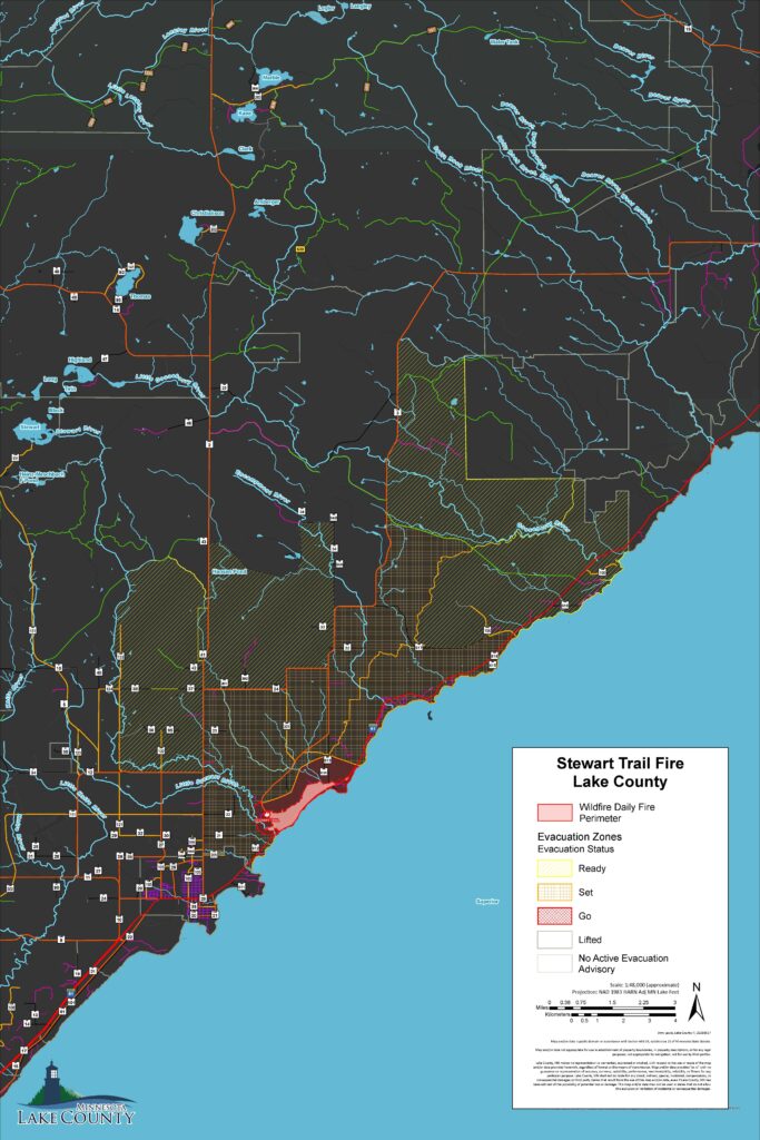
Evacuations: Lake County has reduced portions of the evacuation zone, and the Ready, Set, Go notification plan remains in effect. Current evacuation information can be referenced on the Lake County Fire Evacuation | Lake County Atlas Parcel Viewer.
Weather: Today, temperatures in the high 40’s, with northeasterly winds in the morning. Relative humidity up to 80%. Northeasterly winds increase to 6-14mph this evening, gusting to 25mph throughout the night. Precipitation potential increases throughout the evening, with a slight chance of thunderstorms tonight.
Stewart Trail Fire update
Sunday, May 17, 2026 3:50 PM
Emergency Manager- Warren LaPlante
The Lake County Sheriff’s Office, in coordination with the Minnesota Incident Command System (MNICS) team and the Lake County Emergency Manager, has reduced portions of the evacuation zone related to the Stewart Trail Fire.
The updated evacuation map is available on the Lake County website, and a direct link is provided below. Changes to the evacuation area were made based on the current size, status, and behavior of the fire.
Residents are encouraged to carefully review the updated map to determine the current status of their area. Locations that are no longer within the active evacuation zone have been moved to “SET” status. Residents in these areas should remain prepared to evacuate if conditions change.
The Highway 61 detour remains in effect at this time. Motorists are asked to continue following posted detour routes and avoid the fire area to allow emergency personnel to operate safely.
However, portions of Highway 61will be reopened for local traffic returning to homes in areas that were previously under evacuation orders. Again, Highway 61 will remain closed to through traffic between the Stewart River and the Silver Cliff Tunnel.
Follow this link for updated Evacuation Zones:
https://experience.arcgis.com/experience/10688a627618414fa96159e8f70cba3c/page/Fire-Evacuation
Stewart Trail Update
Sunday, May 17, 2026 12:15PM
MNICS Team A, Incident Commander Mike Hill
Online: https://inciweb.wildfire.gov/incident-information/mnmns-stewart-trail
Fire Information Line: 218-216-6884, 8:00 AM – 8:00 PM
Email: 2026.StewartTrail@firenet.gov
Facebook: https://www.facebook.com/mnics.org
Stewart Trail Fire Quick Facts
Size: 355 acres Origin: 3 miles north of Two Harbors, Minnesota County: Lake Start Date: May 15, 2026
Cause: Under Investigation Containment: 30% Structures Lost: 34, including 8 primary and 26 outbuildings
Total Personnel: 77
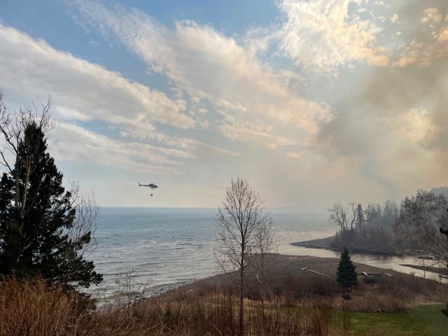
Today’s Highlight: Firefighters quickly responded with aircraft and ground crews to a spot fire along the northern perimeter, limiting fire spread even with the high winds and increased fire danger yesterday afternoon.
Operations: Firefighters assessed and strengthened the control lines. This included creating a Two-blade wide dozer line along the western side and cold trailing around the southern hand line, which means they checked for heat and wet down the area. Firefighters worked to contain a spot fire on the northeastern corner of the fire. Numerous aircraft provided water drops. Firefighters were able to get a better assessment of the fire size, and the acreage has been updated to 355 acres. Local fire departments worked on structure protection by mopping up to remove any hot spots within 50 feet around each structure. Crews continued containment and monitoring overnight, watching for flare-ups and areas of heat throughout the entire area.
Planned Activity: Crews continue to strengthen the dozer line and add hose line to areas along the northern perimeter. Structure protection will continue, and crews will increase the area around structures by doing mop-up and removing hot spots 100 feet or more around each structure.
Aircraft will continue to provide assistance with water and fire-retardant drops. A temporary flight restriction (TFR) is in place. A TFR restricts aircraft from entering the designated area to ensure safety during firefighting operations. Do not fly unauthorized drones near the Stewart Trail Fire. Remember – If you fly, we can’t!
Closures: Due to impacts from heavy smoke and firefighting resources, U.S. Highway 61 is closed at County Highway 2 in Two Harbors and at County Highway 106 (West Castle Danger Road) in Castle Danger, Minnesota. A detour has been set up from Silver Bay to Two Harbors for those who need to travel around the area. For more information, people can visit http://511mn.org for updates from MNDOT.
The public is asked to follow the detour around Highway 61 and stay out of the closure area for their safety.
Evacuations: Lake County has implemented the Ready, Set, Go notification plan. Current evacuation information can be referenced on the Lake County Fire Evacuation | Lake County Atlas Parcel Viewer.
Weather: Today, temperatures will be in the upper 40s. The humidity is higher today, around 58 percent. Winds shift to easterly today and will increase with speeds around 8 -17 mph in the morning and 18-21 with wind gusts of 30-35 late afternoon. Rain showers and storms are predicted to bring ¾ – 1 inch of precipitation late afternoon.
Stewart Trail Fire update
Sunday, May 17, 2026 9:40 AM
Emergency Manager- Warren LaPlante
As of this morning, the fire has remained within the same footprint as yesterday. Conditions continue to be monitored closely. Fire crews continue structural protection efforts, and firefighters remain actively engaged in containment operations throughout the incident area.
At this time, there are no changes to evacuation zones. For public safety, all residences and properties within the evacuation zone remain closed to public access. Re-entry is prohibited until further notice
.If you have questions regarding your property within the evacuation zone, please call the MNICS Public Information line at 218-216-6884 and leave your name and phone number. A coordinated response will be provided as information becomes available.
The Sheriff’s Office is working to contact all property owners whose structures sustained damage. During last evening’s press conference, the Lake County Sheriff reported that 34 structures were damaged, including 8 primary residences.
The shelter at Sonju Arena has been closed at this time. Lake County Public Health remains prepared to reopen shelter operations if conditions warrant it.
Stewart Trail Fire update
Saturday, May 16, 2026 7:45 PM
Link to Press Conference Here: Facebook Live Stream
Stewart Trail Fire update
Saturday, May 16, 2026 2:30 PM
Emergency Manager- Warren LaPlante
As of early this afternoon, the fire remained within its current footprint. Conditions continue to be monitored closely as we enter the hottest part of the day and winds remain active. Fire crews are continuing structural protection efforts, and firefighters remain engaged in suppression operations throughout the incident area.
At this time, there are no changes to evacuation zones. For public safety, all residences and properties within the evacuation zone remain closed to public access. Re-entry is prohibited until further notice.
Damage assessment is ongoing. We will provide more information when its available.
To View Evacuation Zones, follow this link: https://experience.arcgis.com/experience/10688a627618414fa96159e8f70cba3c/page/Fire-Evacuation
Stewart Trail Fire update
Saturday, May 16, 2026 10:47 AM
Emergency Manager- Warren LaPlante
Firefighters, including local fire departments from around the northland, battled the fire overnight focusing on structural protection and holding the line. Overnight, firefighters were able to get a better assessment of the fire size, and the acreage has been updated to 376 acres.
An initial Evacuation Point, which has turned into a shelter, was established at the Sonju Arena by Lake County Public Health. Red Cross assisted overnight and St Louis County provided informational support.
This morning at 06:00 a.m. a Type III IMT assumed command of the fire situation in Unified Command with Two Harbors Fire Department and Lake County Sheriff.
Lake County has implemented the Ready, Set, Go notification plan. Evacuation zones have been initiated, and the Shirreffs Office went door-to-door in the immediate hazard zone. The evacuation zones map can be found on the Lake County website by clicking on the “Lake County Mapping and Online Parcel Mapping” which is located on the main page, then clicking on the bottom right tab of the map titled fire evacuation.
Due to impacts from heavy smoke and firefighting resources, U.S. Highway 61 is closed at County Highway 2 in Two Harbors and at County Highway 106 (West Castle Danger Road) in Castle Danger, Minnesota. A detour has been set up from Silver Bay to Two Harbors for those who need to travel around the area. For more information, people can visit http://511mn.org for MNDOT updates.
The public is asked to follow the detour around Highway 61 and stay out of the closure area for their safety.
Please visit the Lake County website for continued updates on the fire.
To View Evacuation Zones, follow this link: https://experience.arcgis.com/experience/10688a627618414fa96159e8f70cba3c/page/Fire-Evacuation